Services for exploration licenses, mining leases and plants
We work for license holders, investors and operating mines in Balochistan, Khyber Pakhtunkhwa, Gilgit-Baltistan, Punjab and Sindh. Take a single service or hand us the whole program.
GEO · field geology
Geological exploration
Programs that find out quickly whether a license is worth the next rupee, and say so plainly.
We plan and run exploration for metallic and industrial minerals: porphyry copper-gold, skarn and greisen tungsten, placer and lode gold, antimony, barite, chromite and more. Every program starts from a desk study and a remote sensing screen, so the field days go to the ground that earned them.
Field work
Geological and alteration mapping
Rock chip, channel and grab sampling with QA/QC standards and blanks
Soil and stream-sediment grids, designed from target size and terrain
Placer sampling on river banks and terraces, with bulk washing to black sand
Portable XRF screening with lab confirmation
Planning and interpretation
Exploration plans with phased budgets per lease
Target generation and ranking for drilling
Drill program design, core logging and sampling protocols
Integrated geology, geochemistry and geophysics maps
Due diligence on licenses offered for acquisition or joint venture
GPH · applied geophysics
Geophysical surveys
Mineral geophysics, from survey design to the interpreted map.
We plan, acquire, process and interpret the geophysical methods that find ore: magnetic surveys first, and induced polarization, electromagnetics, radiometrics and the rest wherever the target calls for them. Surveys are designed around the deposit model and the terrain, so the data answers the question the license is asking.
Method
What it measures
Typical targets
Magnetic surveys
Variations in the earth's magnetic field from magnetite and pyrrhotite
Intrusions, alteration zones, faults, skarns, magnetite and chromite bodies
Induced polarization (IP) and resistivity
Chargeability and resistivity of the ground
Disseminated sulfides in porphyry, epithermal and VMS systems
Survey design: line spacing, station interval and orientation to strike
Ground magnetic data acquisition, including mountain terrain
Diurnal correction and positioned stations
Daily QC of noise, spikes and coverage
Magnetic surveys: processing
Total magnetic intensity and reduced-to-pole grids
Derivatives, analytic signal and filtering
Depth estimates and 2D/3D modeling
Structural interpretation tied to geology and remote sensing
IP, EM and other methods
Survey design and field supervision
Pseudosections, inversions and plan maps
Integration with geochemistry and drilling
Contractor and airborne surveys
Specifications and tender review
QC of ground and airborne data
Independent interpretation reports
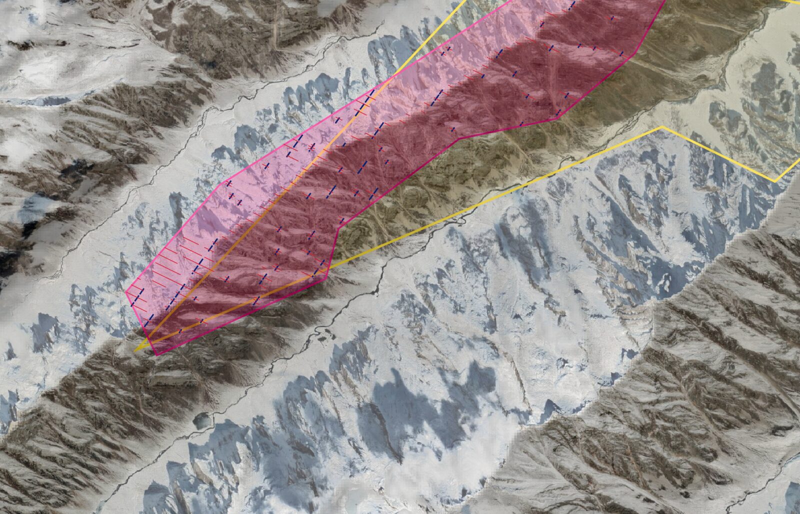
Fig. 2Magnetic survey corridor laid out along a ridge, with lines set to the walkable ground.Planned on satellite imagery before mobilization
RS · satellite and spectral
Remote sensing studies
The fastest, cheapest look at a whole license. Our most requested service.
Multispectral and hyperspectral mapping of hydrothermal alteration, lithology, structure and vegetation stress, delivered as ranked targets with field coordinates. We cover the method and our deliverables on a page of its own.
The paperwork that keeps a mineral title alive, prepared by the people who did the geology.
Provincial Mines & Minerals Departments and Directorates ask license and lease holders for a steady flow of technical documents: at application, at grant, every year, at renewal, and whenever a letter arrives. We prepare them in the format each department expects, from data we can stand behind, and we keep track of what is due next.
Exploration licenses (EL / PL)
Geological reports for new applications and extensions
Exploration work programs with schedules and budgets
Quarterly and annual progress reports
Remote sensing justification for area additions and relinquishments
Renewal and conversion files
Mining leases (ML) and operations
Mining schemes and feasibility reports
Production plans, machinery and manpower lists
CSR plans for local communities
Dues and royalty statements, compliance cover letters
Replies to department letters and show-cause notices, point by point
Maps to the department's standard
Lease boundary maps with area statements
Location, geological and sample maps for each report
Overlap checks before you apply
Who we file with
Mines and minerals departments of Balochistan
Khyber Pakhtunkhwa, including the merged districts
Gilgit-Baltistan, including its mineral directorate
Punjab and Sindh
MPD · mineral processing
Mineral processing plant design
Flowsheets sized to the ore, the budget and what local workshops can build.
We have run plants as well as drawn them. Our designs favor robust gravity and flotation circuits that local fabricators can make and local crews can maintain, with the reporting needed to know what the plant actually produced.
Design
Gravity circuits: crushing, screening, classifying, spirals and shaking tables
Barite washing and upgrading to drilling-grade specification
Placer gold recovery plants for river and terrace gravels
Bench-scale flotation testing and SOPs
Operation
Equipment lists and procurement workbooks
Tonnage estimation and production reporting
Product grading against buyer specifications
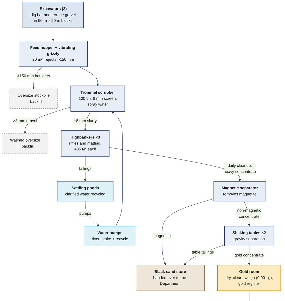
Fig. 3Flowsheet for a river-gravel placer gold plant: screening, sluicing, magnetic separation and tabling to a gold room, with water recycled.Placer gold mining lease, Gilgit-Baltistan
GIS · data
GIS, topographic surveys and data management
The ground measured, the files organized, one dataset you can query.
Most exploration companies hold their data in spreadsheets, shapefiles, Google Earth folders and old PDFs. We survey what is missing, clean what exists, link it to the right lease and put it in a structure your team and your regulator can use. For ongoing work, that structure is dbmine.
Topographic surveys
DGPS and total station surveys
Drone mapping, orthophotos and elevation models
Contour and site plans for mines and plants
Boundary pillar demarcation
Pit, dump and stockpile volumes
GIS
Lease and license boundary maps
Map production for reports, print and web
KML and KMZ archives organized by project
Data management
Database design for samples, assays, surveys and drilling